Pocosins are a unique type of wetland found in the North Carolina coastal plain. They provide valuable wildlife habitat and store large amounts of carbon in their deep peat soils. Many pocosins in North Carolina have been altered by drainage, land clearing, or plantation forestry. There is increasing interest in pocosin restoration as a nature-based solution that will benefit both natural ecosystems and people. Some restoration projects on both public and private land are already underway, including the Duke Carbon Farm project.
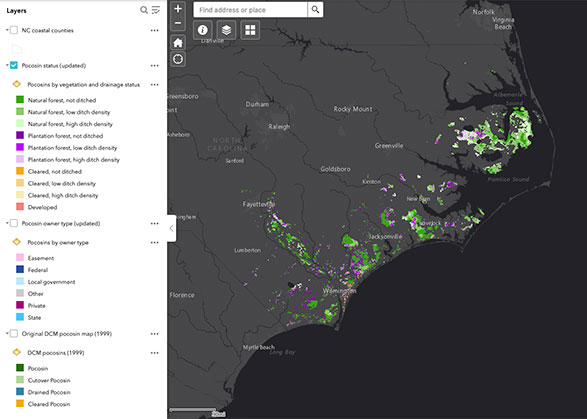
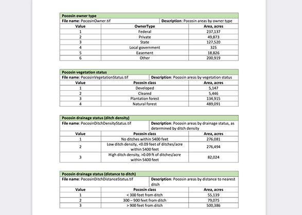
To help identify opportunities for pocosin restoration and as a first step to improving estimates of carbon storage by pocosins, the Nicholas Institute created updated maps of pocosin status (vegetation and drainage) and owner type, building on the existing wetlands maps developed by the North Carolina Division of Coastal Management in 1999. Estimates on carbon stored in the pocosin soils and potential carbon benefits from restoring degraded pocosins are based on the NC Soil Survey and data from the Duke Wetlands Center.
Thanks to Curt Richardson (Duke), Michael Schafale (NC Natural Heritage Program), Scott Pohlman (NC Natural Heritage Program), Sara Ward (US Fish & Wildlife Service), and the rest of the NWL pocosins subcommittee for sharing their pocosin expertise and providing input on the map updates, and to Matthew Fagan (University of Maryland, Baltimore County) for sharing his plantation forests dataset. This work was funded by the Southeast Climate Adaptation Science Center.